6 Tage
ab 1295,00 €
vom 19.05. bis 24.05.
Nur noch 1 Platz verfügbar.
Nur noch 1 Platz verfügbar.


Unsere Bergschule in Oberstdorf bietet für Sie den perfekten Rundum-Service. Egal ob eine Alpenüberquerung auf dem anspruchsvollen Fernwanderweg E5 von Oberstdorf bis Meran oder eine einfache 3-Tage durch die Allgäuer Alpen-Tour .
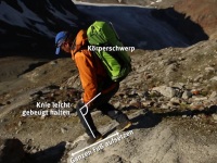
Unsere staatlich geprüften und qualifizierten Bergführer sorgen für einen reibungslosen Ablauf der Tour, so dass Sie sich auf das Wandererlebnis konzentrieren können. Unsere Bergschule in Oberstdorf unterstützt Sie auch in der Vorbereitung für Ihre Wanderungen. Nutzen Sie unsere Service-Angebote, und schauen Sie sich z.B. unsere Tipps zu Wanderrucksack richtig packen an.
Unsere Experten planen ihre Tour - Bei uns können Sie auch frei, unabhängig und individuell Wandern .
Im Winter können Sie mit unseren Bergführern Scheeschuhwandern oder auch Skitouren gehen .
Die Highlight-Touren in unserer Region sind der Heilbronner Höhenweg und die Steinbocktour. Suchen Sie mehr als einen einfachen Wanderweg oder eine Hüttenwanderung? Dann lassen Sie sich von unserer Tourenübersicht inspirieren. Wir bieten Ihnen auch spezielle Wandern mit Komfort bei dem wir uns um Ihren Gepäcktransport während der Bergwanderung kümmern.


Bergschulleiter
staatl. geprüfter Berg- und Skiführer
staatl. geprüfter Skilehrer
Bergschule in Oberstdorf
Bahnhofsplatz 5 | 87561 Oberstdorf
bergschule@oase-alpin.de
+49 8322 8000 980


 möglich")